Is Greenland really as large as all of Africa? Does Alaska dwarf Mexico? Why does Russia appear to dominate half the planet? TrueSize.net (truesize.net) answers these questions with an interactive tool that shatters one of geography’s most persistent illusions: the Mercator projection. By letting you drag countries around the globe and watch their sizes change, TrueSize reveals how traditional flat maps have been deceiving us about the true scale of our world.
What Is TrueSize?
TrueSize (officially ThetrueSize.com, with multiple variants at truesize.net and related domains) is a free, browser-based interactive map tool that demonstrates the true relative sizes of countries, regions, and continents without the distortion inherent in traditional flat map projections. The tool allows users to drag any country or region across the map and watch it dynamically resize, revealing its actual area compared to other locations.
The platform has become a viral educational phenomenon, used by geography teachers worldwide to demonstrate cartographic principles and challenge students’ geographic misconceptions. It’s the perfect antidote to decades of misleading maps that make Greenland appear larger than Africa (when Africa is actually 14 times bigger).
The Mercator Problem
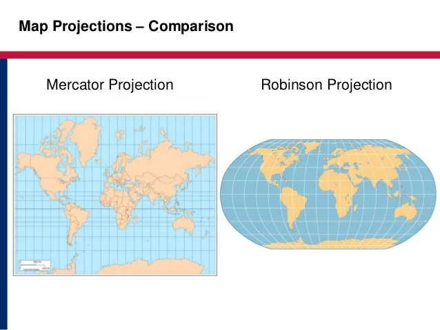
To understand why TrueSize matters, you need to understand the problem it solves. The Earth is a sphere, but most maps are flat rectangles. Converting a sphere to a rectangle requires distortion—something has to give.
The Mercator projection, created in 1569 for ship navigation, preserves angles and shapes but dramatically distorts sizes, especially near the poles. Countries far from the equator appear much larger than they actually are:
- Greenland appears similar in size to Africa, but Africa is actually 14× larger
- Alaska looks bigger than Mexico, but Mexico is actually 1.3× larger
- Scandinavia appears larger than India, but India is actually 3× bigger
- Antarctica looks massive, but it’s actually smaller than Africa
This distortion isn’t malicious—Mercator projection was designed for navigation, where straight lines are crucial. But using it for general geographic education creates lasting misconceptions about global geography.
How TrueSize Works
Using TrueSize is remarkably simple:
- Search for a Country: Type any country, region, or U.S. state into the search bar
- Drag It Around: Click and drag the highlighted shape anywhere on the map
- Watch It Resize: As you move toward or away from the equator, the shape dynamically adjusts to its true relative size
- Compare Multiple Regions: Add several countries to compare them side-by-side
- Share Your Discovery: Screenshot or share the link to show others
The effect is immediate and often shocking. Drag Greenland down to the equator and watch it shrink to a fraction of its apparent size. Slide Africa up toward the Arctic and watch it maintain its massive scale.
Key Features
Comprehensive Global Database
Search any country, territory, continent, ocean, major lake, or U.S. state. The database covers essentially every named region on Earth.
Real-Time Size Adjustment
As you drag shapes across latitudes, they resize dynamically based on their true surface area. This visual demonstration is far more powerful than simply stating numeric comparisons.
Multiple Overlays
Add multiple countries simultaneously to create direct side-by-side comparisons. Overlay the United States onto Brazil, or compare India to Scandinavia.
Coordinate Display
See the exact latitude and longitude of each shape’s center point, plus the Mercator exaggeration ratio showing how much the projection distorts size at that location.
Transparency Controls
Adjust shape transparency to see underlying geography, useful when overlaying multiple regions.
Rotation Tools
Rotate shapes to align them better for comparison or to match orientation.
Background Options
Switch between standard map view, satellite imagery, or terrain backgrounds depending on your needs.
Share Functionality
Every configuration can be shared via direct link, allowing you to send specific comparisons to others or embed them in educational materials.
Eye-Opening Comparisons
Using TrueSize reveals surprising geographic truths:
- Africa vs. Everyone: Africa fits the United States, China, India, Europe, and Japan combined within its borders
- Brazil vs. Greenland: Brazil is actually 4× larger than Greenland (despite appearances)
- India vs. Scandinavia: India is 3× larger than Sweden, Norway, and Finland combined
- Russia Reality Check: While Russia is genuinely huge, Mercator exaggerates it even more—it’s actually “only” 1.8× larger than the United States, not the 3-4× it appears
- Alaska vs. Mexico: Mexico is actually 1.3× larger than Alaska
- Continental Surprises: South America is significantly larger than Europe
Educational Applications
TrueSize has become an essential tool for geography education:
- Map Projection Lessons: Demonstrate why no flat map can perfectly represent a sphere
- Scale Understanding: Help students grasp true geographic relationships
- Critical Thinking: Question visual information and understand how representation affects perception
- Colonial History: Discuss how Mercator projection influenced perceptions of European dominance
- Climate Discussions: Understand true land mass distribution for environmental conversations
- Travel Planning: Grasp actual distances and scale for trip planning
Strengths
- Completely Free: No subscriptions, accounts, or payments
- Instant Understanding: Visual demonstration more powerful than numbers
- Universal Access: Works on any device with a browser
- Educational Gold: Perfect for classrooms and homeschooling
- Engaging Interaction: Dragging countries is genuinely fun
- Mind-Blowing Revelations: Challenges decades of geographic misconceptions
- Share-Worthy: Easy to show friends specific comparisons
- No Learning Curve: Intuitive interface anyone can use immediately
- Global Coverage: Includes every country and major region
- Privacy-Focused: No data collection or tracking
Limitations
- Surface Area Only: Doesn’t account for population, GDP, or other metrics
- Simple Tool: Does one thing (shows size) without additional geographic data
- No Save Function: Can’t save custom comparisons (must screenshot or share link)
- Mobile Experience: Works but less smooth than desktop; dragging can be finicky on small screens
- Limited Data Display: Doesn’t show actual square kilometers/miles numerically
- Single Projection Focus: Only demonstrates Mercator issues, not other projection types
Who Should Use TrueSize?
TrueSize serves multiple audiences:
- Teachers: Geography, social studies, and earth science educators
- Students: Anyone learning about world geography
- Parents: Homeschooling families teaching geography
- Travelers: Understanding true scale of destinations
- Geography Enthusiasts: Map lovers and trivia fans
- Trivia Buffs: Settling geographic debates with friends
- Content Creators: Journalists and bloggers discussing geography
- Anyone Curious: People who wonder why maps look weird
The Broader Implications
TrueSize isn’t just about correcting map distortion—it raises important questions about how visual representations shape our understanding of the world. When Africa appears smaller than it truly is, and Europe appears larger, these distortions can subtly influence perceptions of global importance, population distribution, and geopolitical significance.
The tool serves as a reminder that all representations involve choices and trade-offs. Understanding these limitations helps us think more critically about information presented to us.
Similar Tools and Variations
The TrueSize concept has spawned several related implementations:
- TrueSize.world: Enhanced version with more features and customization
- TrueSizeOf.net: Alternative interface with similar functionality
- Mobile Apps: Official TrueSize apps available for iOS and Android
- Classroom Presets: Some versions offer pre-configured famous comparisons
Tips for Best Experience
- Start Dramatic: Begin with Greenland vs. Africa for maximum impact
- Compare Neighbors: Drag adjacent countries over each other to compare
- Equator Test: Move every country to the equator to see true sizes
- Use Desktop: Larger screen makes comparisons easier to see
- Screenshot Discoveries: Capture surprising comparisons to share
- Try Multiple Overlays: Stack 3-4 countries for complex comparisons
Final Verdict
TrueSize.net is one of those rare tools that fundamentally changes how you see the world—literally. Within minutes of playing with it, decades of geographic misconceptions begin to crumble. The simple act of dragging Greenland down to the equator and watching it shrink is genuinely revelatory.
For educators, it’s an invaluable teaching tool that makes abstract cartographic concepts immediately concrete. For students, it transforms geography from memorizing names and locations to understanding spatial relationships. For everyone else, it’s a fascinating way to spend 20 minutes questioning everything you thought you knew about map sizes.
The tool’s singular focus is both its strength and limitation. It does one thing—show true country sizes—and does it brilliantly. It won’t teach you capital cities or population statistics, but it will forever change how you look at world maps.
In an era of misinformation and misleading visuals, TrueSize stands as a reminder that even something as seemingly objective as a map involves choices that affect our understanding. And the best part? Understanding these distortions is just a drag-and-drop away.
Rating: 5 out of 5 stars
Best for: Geography teachers, students, curious minds, anyone who’s ever looked at a world map and thought something seemed off
Price: Completely free
Website: truesize.net (also available at thetruesize.com and related domains)